Total Population: 5,500,000 (Republic of Ireland 4,000,000. Northern Ireland 1,500,000)
Main Cities and Population
- Dublin: 1,122,821
- Cork: 186,239
- Limerick: 86,998
- Waterford: 46,736
Land
- Total area 84,421 sq. km (Republic of Ireland 70,282 sq. km. Northern Ireland 14,139 sq. km)
- Highest mountain Carrantuohill 1,041 metres
- Longest river, Shannon 340 km
- Largest lake, Lough Neagh 396 sq km
- Highest waterfall Powerscourt 122 m
Land Divisions
Historically, Ireland is divided into four ancient provinces, LEINSTER, MUNSTER, CONNACHT and ULSTER which are further divided into 32 Counties: 26 Counties in The Republic of Ireland. 6 Counties in Northern Ireland
Climate
The North Atlantic currents bring lots of rain to Ireland, especially along its Atlantic Ocean coastline. Winters here are quite moderate, with some snow in the higher elevations and mountains. The east coast, including Dublin, is warmer with much less rain.
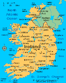
IRELAND PROVINCES AND COUNTIES
LEINSTER PROVINCE
Leinster is the most easterly of the Irish provinces and includes counties Carlow, Dublin, Kildare, Kilkenny, Laois, Longford, Louth, Meath, Offaly, Westmeath, Wexford and Wicklow
MUNSTER PROVINCE
Munster is the most southern of the provinces, consisting of counties Clare, Cork, Kerry, Limerick, Tipperary and Waterford.
CONNACHT PROVINCE
Connacht is the smallest and most westerly of the four provinces. It includes counties Galway, Mayo, Sligo, Roscommon and Leitrim.
ULSTER PROVINCE
Ulster is the most northerly of the four historic provinces. It consists of counties Antrim, Armagh, Cavan, Derry, Donegal, Down, Fermanagh, Monaghan and Tyrone